• MONITORING
  • MAPPING
    • Home
    • About
      • About Us
      • Our Team
      • News & Views
      • Events
      • Sustainability and the Environment
      • Case Studies
      • Careers
      • Contact Us
    • Industries
      • Ports and Harbours
      • Maritime Pilotage
      • Bridges and Inland Waterways
      • Offshore Renewables
      • Governments and Agencies
      • Case Studies
    • Compliance
      • Compliance Overview
      • Marine Data Management
      • Asset Management System
      • Spatial Data Management & GIS
      • Our Courses
    • Training
      • Our Courses
      • Data Management
      • Data Management for Ports
      • Data Management, Governance and MEDIN toolset
      • Data Management and Marine Spatial Data Infrastructure (SDI)
      • Technical Training
    • Partners
      • Licenced Partners
      • Partner’s Resource Hub
    • Support
      • Resources
      • Support
      • Contact Us
banner

ESA Funded A-SeNS enables Port-Log Data to be captured by Satellites

By Katie Edies 3rd February,2026

ESA Funded A-SeNS enables Port-Log Data to be captured by Satellites

OceanWise Global > News & Projects > Uncategorised > ESA Funded A-SeNS enables Port-Log Data to be captured by Satellites

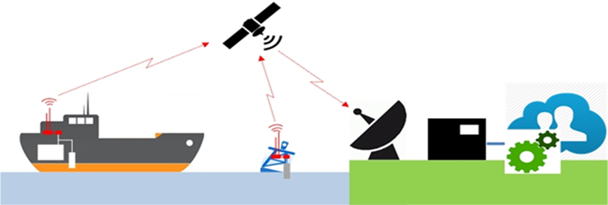
The Automatic Identification System (AIS) is a tracking system used by ships and vessel traffic services for identifying and locating vessels by electronically exchanging data with other nearby vessels, shore stations and satellites. As well as providing information such as vessel location, speed and direction, AIS is capable of handling environmental data, such as wind speed, direction and tide height from weather stations and tide gauges, and water depth from vessel echo sounders.

A-SeNS is a European Space Agency (ESA) funded project that aims to demonstrate the capture of environmental data by satellite (see image below). The project extends OceanWise’s Environmental Data Sharing and Publishing capability by enabling data captured by monitoring stations and managed in Port-Log to be transmitted via an AIS transceiver. The satellites are operated by exactEarth Europe who is leading the project.

The project involves adding new software code to OceanWise’s Smart Telemetry Unit, thus saving space and power in a fully integrated system. The code packages the data according the International Maritime Organisation’s (IMO) TideMet specification and allows the data to be received locally by vessels as well as by the exactEarth satellites. The data can then be shared more widely for navigation, survey and other maritime operations.

aSens

View all Guides and insights

About Us

f 𝕏 in 📷

Services

  • Environmental Monitoring
  • Port-Log Data Platform
  • Marine Mapping
  • Spatial Data & GIS
  • Training Courses
  • Compliance
  • Asset Management System

Company

  • News & Projects
  • Events
  • Newsletters
  • About Us
  • Partners
  • Our Team
  • Sustainability and the Environment
  • Careers

Resources

  • Contact Us
  • Brochures, Data Sheets and Guides
  • Monitoring Support
  • Mapping Support
  • Case Studies

Newsletter

Subscribe to our newsletter for updates and exclusive content.

© 2025 Oceanwise. All rights reserved.

Privacy Policy | Terms of Service | Cookie Policy

© OceanWise 2024. OceanWise Limited is an independent company specialising in marine environmental data acquisition, management, publishing and GIS.
Registrar of Companies of England and Wales No. 7206926 and Companies Registration Office Ireland No. 641571.

Terms & Conditions | Privacy Notice | Contact Us

OceanWise HelpBot

Still need help?
This site uses cookies: Find out more.