• MONITORING
  • MAPPING
    • Home
    • About
      • About Us
      • Our Team
      • News & Views
      • Events
      • Sustainability and the Environment
      • Case Studies
      • Careers
      • Contact Us
    • Industries
      • Ports and Harbours
      • Maritime Pilotage
      • Bridges and Inland Waterways
      • Offshore Renewables
      • Governments and Agencies
      • Case Studies
    • Compliance
      • Compliance Overview
      • Marine Data Management
      • Asset Management System
      • Spatial Data Management & GIS
      • Our Courses
    • Training
      • Our Courses
      • Data Management
      • Data Management for Ports
      • Data Management, Governance and MEDIN toolset
      • Data Management and Marine Spatial Data Infrastructure (SDI)
      • Technical Training
    • Partners
      • Licenced Partners
      • Partner’s Resource Hub
    • Support
      • Resources
      • Support
      • Contact Us
banner

DelNorte and OceanWise deliver Tidal Level System to RNLI

By Katie Edies 3rd February,2026

DelNorte and OceanWise deliver Tidal Level System to RNLI

OceanWise Global > News & Projects > Uncategorised > DelNorte and OceanWise deliver Tidal Level System to RNLI

DelNorte in conjunction with OceanWise has delivered a new online tidal level system to the Royal National Lifeboat Institution (RNLI) to assist its crews to safely launch its rescue craft from its new Lifeboat station at Portishead, Avon, UK.

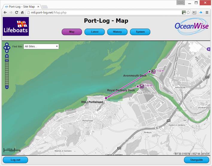
With a tidal range in excess of 12 metres in this part of the Bristol Channel, the life-boat crews have to make quick decisions based on the prevailing conditions as to whether they are able to launch the life boat from the outer slipway, or from within Portishead harbour. Tidal elevations have been kindly provided by the Port of Bristol, via UHF link from their gauges at Avonmouth and Royal Portbury Dock from where the real-time tidal level data is posted to the OceanWise Port-Log subscription service and made available online to the RNLI crews and its operation control.

Due to the complexity of the tides in the area, special analyses are undertaken to detect rapid rates of change and ensure that the latest information is available immediately to the crews.

A RNLI spokesperson stated that he was “very happy with the system” and that the “smartphone access was a revelation!”

Try the Port-Log.net service out for yourself.

image1

View all Guides and insights

About Us

f 𝕏 in 📷

Services

  • Environmental Monitoring
  • Port-Log Data Platform
  • Marine Mapping
  • Spatial Data & GIS
  • Training Courses
  • Compliance
  • Asset Management System

Company

  • News & Projects
  • Events
  • Newsletters
  • About Us
  • Partners
  • Our Team
  • Sustainability and the Environment
  • Careers

Resources

  • Contact Us
  • Brochures, Data Sheets and Guides
  • Monitoring Support
  • Mapping Support
  • Case Studies

Newsletter

Subscribe to our newsletter for updates and exclusive content.

© 2025 Oceanwise. All rights reserved.

Privacy Policy | Terms of Service | Cookie Policy

© OceanWise 2024. OceanWise Limited is an independent company specialising in marine environmental data acquisition, management, publishing and GIS.
Registrar of Companies of England and Wales No. 7206926 and Companies Registration Office Ireland No. 641571.

Terms & Conditions | Privacy Notice | Contact Us

OceanWise HelpBot

Still need help?
This site uses cookies: Find out more.