
Despite ever-increasing global recognition on the importance of sea level data to inform decision makers on climate and environmental policies, there was insufficient data to update the UK sea-level index in both 2020 and 2021 (Kendon et al. (2022).
However, data quality and reliability are now back on track and the tide gauge network is at a high enough standard to calculate this vital statistic. Importantly, the Environment Agency (EA) have been able to submit mean sea level values, for the purposes of tracking sea level rise, in 2022.
What has changed?
In late 2021 OceanWise were awarded the Environment Agency’s contract to maintain and update the United Kingdom’s National Tide Gauge Network (NTGN) which underpins coastal flood forecasting around the UK and comprises a network of 42 tide gauges sited at key locations.
On taking on the contract OceanWise became responsible for ensuring the real-time stream of high-quality data from the network, whilst sympathetically maintaining the legacy sensors to maintain the long-term data record. OceanWise achieve this by providing maintenance, systematic improvements and quickly responding to any ad hoc faults that might arise.
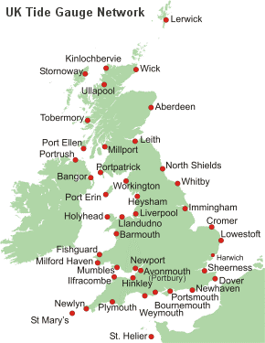
Above image shows all 42 tide gauges across the UK. Image source / credit: https://ntslf.org/
As our CFO, Dr Mike Osborne explains, “We are delighted to have been given the responsibility of maintaining the NTGN on behalf of the nation. We have particularly enjoyed working with the EA and NOC to upgrade the network, using our expertise and experience in sensor, and data acquisition and management technologies, whilst at the same maintaining and enhancing the legacy ‘bubbler’ based systems to improve the reliability and quality of the data overall“.
More about the NTGN
The purpose of the (NTGN) is to observe sea level throughout the UK in near real-time, as input to monitoring and forecasting coastal surge, and to provide a long-term and strategic record for climatological and coastal engineering studies. The network currently consists of 21 sites in England, 10 in Scotland, 7 in Wales, 2 in Northern Ireland, 1 in Jersey and 1 in the Isle of Man.
The data provided by the network of gauges is also used by academics and researchers for a variety of other scientific purposes. Several of the gauges are part of the Global Sea Level Observing System (GLOSS) and are of international and historical significance, with some datasets dating back to the 18th century.
Read more about the UK’s data submission in “The State of the UK Climate” which provides a summary of the UK’s weather and climate through the calendar year 2022, alongside historical context for a number of essential climate variables”. See ‘Section 6’ for UK Sea Level.
View all Guides and insights