Accessing real-time marine data
As experts in marine data and data management we are proud to support port operations and maritime pilotage with our range of products and services including:
Access to Environmental Monitoring data via Port-Log
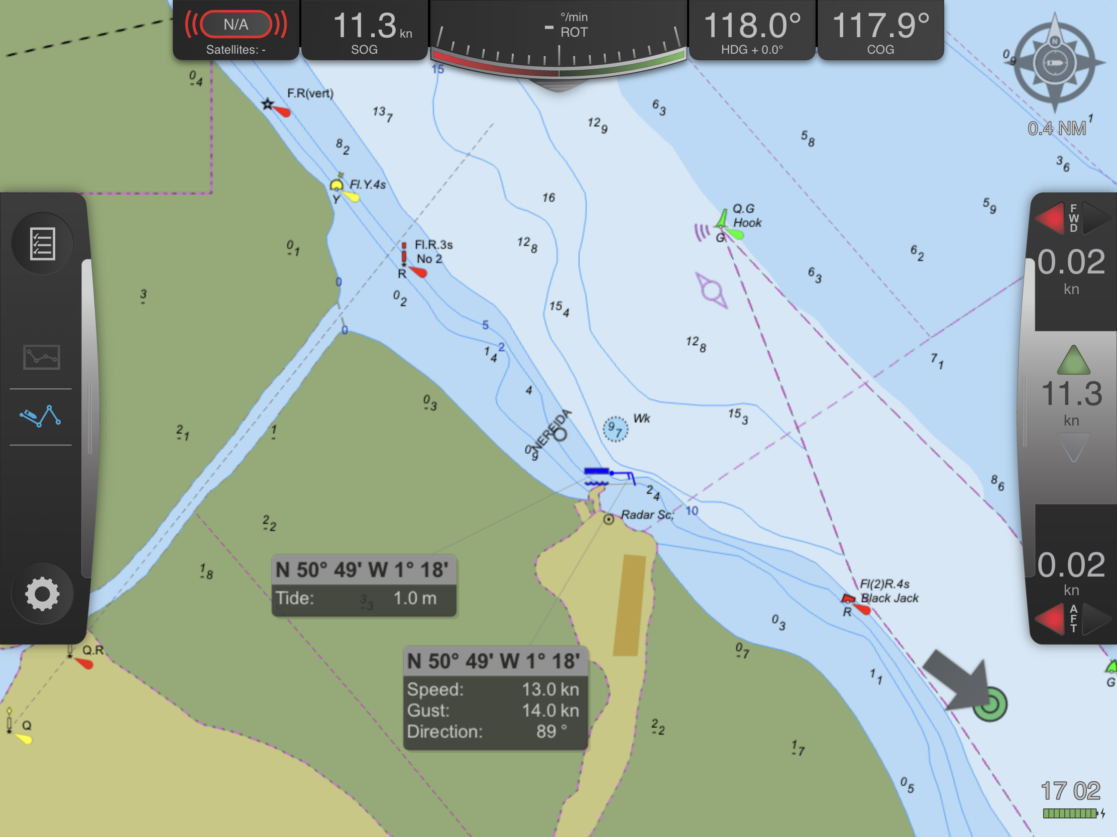
View real-time tide, weather and other important environmental data from Port-Log on your PPU. We work closely with our customers and PPU manufacturers, to ensure that essential data is available to those who need it, when they need it. See our news item here to see how ABP Southampton have made tide and weather data available to pilots via their Trelleborg 'Safe Pilot' PPU.
ENC Writer Software
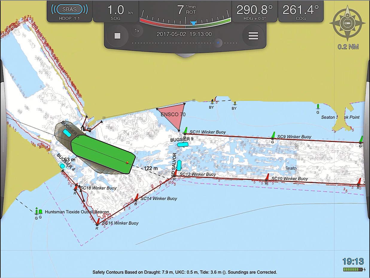
Our ENC Writer allows you to create Bathymetric and Port ENCs easily within an integrated system which can be viewed on your PPU. Using our software, ENCs can be produced within hours of receipt of the latest survey data, which means that pilots are assured they are getting the most up-to-date and accurate information - reducing risk and increasing confidence. The QPS Qastor PPU has proven compatibility with our ENC Writer and has been deployed at PD Ports supporting pilotage and safe vessel passage.
See our
case study for insight on how Peel Ports use our ENC Writer to safely navigate vessels on the River Clyde.
Read more on ENCs for ports
Marine mapping data
Our intelligent marine and coastal mapping data are designed to be compatible with all leading desktop and web-based Geographical Information Systems (GIS). They are quick and easy to use in planning, engineering, asset management, operations, regulation and a multitude of other applications.
For an overview of our range of mapping products - see our
data buying guide
Proven compatibility with PPU's
Trelleborg 'Safe Pilot' - ABP Southampton & PD Ports
We would welcome other opportunities to test the compatibility of Port-Log and our Bathymetry and Port ENC software with other PPUs. If you are a user of PPUs or a PPU manufacturer then please do
contact us.
Port-Log Demo Page
View a variety of real-time data feeds on our free demonstration site
View Here
Accessing real-time marine data
As experts in marine data and data management we are proud to support port operations and maritime pilotage with our range of products and services including:
Access to Environmental Monitoring data via Port-Log
View real-time tide, weather and other important environmental data from Port-Log on your PPU. We work closely with our customers and PPU manufacturers, to ensure that essential data is available to those who need it, when they need it. See our news item here to see how ABP Southampton have made tide and weather data available to pilots via their Trelleborg 'Safe Pilot' PPU.
ENC Writer Software
Our ENC Writer allows you to create Bathymetric and Port ENCs easily within an integrated system which can be viewed on your PPU. Using our software, ENCs can be produced within hours of receipt of the latest survey data, which means that pilots are assured they are getting the most up-to-date and accurate information - reducing risk and increasing confidence. The QPS Qastor PPU has proven compatibility with our ENC Writer and has been deployed at PD Ports supporting pilotage and safe vessel passage.
See our
case study for insight on how Peel Ports use our ENC Writer to safely navigate vessels on the River Clyde.
Read more on ENCs for ports
Marine mapping data
Our intelligent marine and coastal mapping data are designed to be compatible with all leading desktop and web-based Geographical Information Systems (GIS). They are quick and easy to use in planning, engineering, asset management, operations, regulation and a multitude of other applications.
For an overview of our range of mapping products - see our
data buying guide
Proven compatibility with PPU's
Trelleborg 'Safe Pilot' - ABP Southampton & PD Ports
We would welcome other opportunities to test the compatibility of Port-Log and our Bathymetry and Port ENC software with other PPUs. If you are a user of PPUs or a PPU manufacturer then please do
contact us.
Port-Log Demo Page
View a variety of real-time data feeds on our free demonstration site
View Here