• MONITORING
  • MAPPING
    • Home
    • About
      • About Us
      • Our Team
      • News & Views
      • Events
      • Sustainability and the Environment
      • Case Studies
      • Careers
      • Contact Us
    • Industries
      • Ports and Harbours
      • Maritime Pilotage
      • Bridges and Inland Waterways
      • Offshore Renewables
      • Governments and Agencies
      • Case Studies
    • Compliance
      • Compliance Overview
      • Marine Data Management
      • Asset Management System
      • Spatial Data Management & GIS
      • Our Courses
    • Training
      • Our Courses
      • Data Management
      • Data Management for Ports
      • Data Management, Governance and MEDIN toolset
      • Data Management and Marine Spatial Data Infrastructure (SDI)
      • Technical Training
    • Partners
      • Licenced Partners
      • Partner’s Resource Hub
    • Support
      • Resources
      • Support
      • Contact Us
banner

Elane Inc. procures OceanWise Web Mapping Service

By Katie Edies 3rd February,2026

Elane Inc. procures OceanWise Web Mapping Service

OceanWise Global > News & Projects > Uncategorised > Elane Inc. procures OceanWise Web Mapping Service


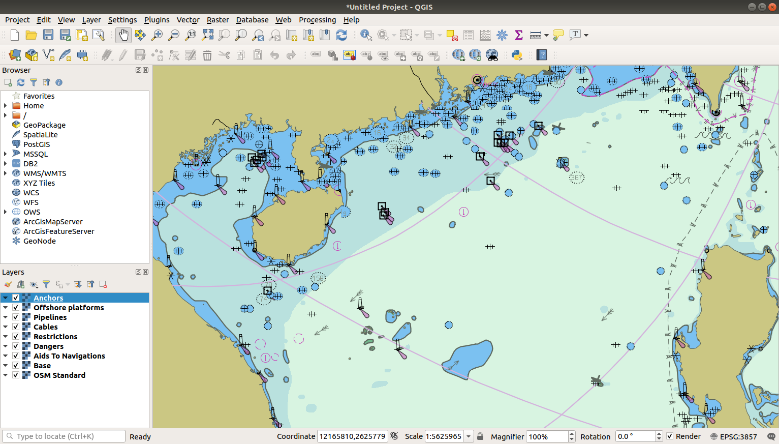
Images above shows example ENC with visible layers (Anchors; Offshore Platforms; Pipelines; Cables; Restrictions; Dangers; Aids to Navigation; Base)

OceanWise has successfully delivered its web mapping service to the global shipping and logistics company Elane Inc.

Based in China, Elane Inc provides data and software services, including real-time dynamic global vessel tracking, to shipping companies, ports, logistics and other industries.

OceanWise has licensed its web mapping service to support Elane’s range of products and services, some of which require contextual background mapping.

The service allows fast and easy access to marine mapping which retains the familiar ‘look and feel’ of standard nautical charts but includes layers which can be switched on and off giving the user the flexibility and control to manipulate the display. As the service provides vector data, the user is guaranteed high quality images, regardless of the display scale selected.

The OceanWise web mapping service has a proven track record (already being used by other global players such as Vattenfall) and can be used in all popular desk-top and web-based GIS systems and support all three popular coordinate reference systems: WGS84 (EPSG:4326); WGS84 / Pseudo-Mercator (EPSG:3857); WGS84 / World Mercator (EPSG:3395).

For more information on OceanWise Mapping products and Service please click here

To view our mapping demonstration site please click here

For more information on Elane, please click here

View all Guides and insights

About Us

f 𝕏 in 📷

Services

  • Environmental Monitoring
  • Port-Log Data Platform
  • Marine Mapping
  • Spatial Data & GIS
  • Training Courses
  • Compliance
  • Asset Management System

Company

  • News & Projects
  • Events
  • Newsletters
  • About Us
  • Partners
  • Our Team
  • Sustainability and the Environment
  • Careers

Resources

  • Contact Us
  • Brochures, Data Sheets and Guides
  • Monitoring Support
  • Mapping Support
  • Case Studies

Newsletter

Subscribe to our newsletter for updates and exclusive content.

© 2025 Oceanwise. All rights reserved.

Privacy Policy | Terms of Service | Cookie Policy

© OceanWise 2024. OceanWise Limited is an independent company specialising in marine environmental data acquisition, management, publishing and GIS.
Registrar of Companies of England and Wales No. 7206926 and Companies Registration Office Ireland No. 641571.

Terms & Conditions | Privacy Notice | Contact Us

OceanWise HelpBot

Still need help?
This site uses cookies: Find out more.